Wildfires rage across northern Portugal, CAMS tracks their impacts
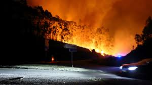
Lisbon: Several significant wildfires have developed in northern Portugal in recent days, causing many fatalities and significant damage to property. As the fires continue to burn, the Copernicus Atmosphere Monitoring Service (*CAMS) has been monitoring and forecasting the behaviour of the smoke plumes and their impact on air quality in the region. Let’s take a closer look at what the data show.
This series of wildfires in northern Portugal started on 14 September and increased significantly in activity during 15-17 September and, according to Portugal’s civil protection service, there are currently 107 active fires mainly in the north of the country, with almost 4,000 firefighters mobilised.
Daily total fire radiative power (FRP) data from the CAMS Global Fire Assimilation System (GFAS) indicate a significant increase in wildfire activity on 16 September, with a further increase in the number of fires and their intensity on 17 September (see below). FRP is observed by satellites and used by CAMS to estimate emissions related to burning vegetation.
As a result, estimated carbon emissions for Portugal in September are already at the highest level for the month in the 22 years of the CAMS Global Fire Assimilation System (GFAS) dataset by a large margin at just over 1.4 megatonnes, with the wildfires in the north of the country accounting for around 1.3 megatonnes of this total.
The wildfires are having a significant negative impact on air quality in the region. The smoke plume from the wildfires has significantly degraded air quality locally and is forecasted to travel across the Iberian Peninsula towards western France in the coming days The CAMS regional and global forecasts show a smoke plume, with high aerosol optical depth (AOD) values, originating from northern Portugal initially moving out towards the Atlantic before circling back across the northern Iberian Peninsula towards the Bay of Biscay and western France in the coming days. AOD is the measure of particulate matter and aerosols, in this case smoke particles, distributed within a column of air from the Earth’s surface to the top of the atmosphere.
In particular, the forecast shows significant levels of PM2.5 over northern Portugal in the period up to 25 September. PM2.5 refers to particulate matter that is 2.5 microns or smaller in diameter, as a result of which it can penetrate deep into the respiratory system and potentially enter the bloodstream, with significant implications for public health. The CAMS forecasts also show high levels of PM10, particulate matter that is 10 microns or smaller in diameter, circulating across northern Portugal and being transported westward over the Atlantic and north-eastward over northern Spain towards France.
“Our data is showing a clear enhancement in the fire emissions and smoke impacts on atmospheric composition and air quality, reflecting the high intensity that rapidly developed with these devastating fires in northern Portugal. The Copernicus Atmosphere Monitoring data, together with the data from the Copernicus Emergency Management Service, help affected countries to assess the impact on the ground and in the air in these very challenging circumstances,” said CAMS Senior Scientist Mark Parrington.
CAMS provides regular up-to-date information on the location, intensity and estimated emissions of wildfires around the world, as well as tracking smoke transport and composition. To learn more about CAMS monitoring of wildfires and smoke, visit our page on Global fire monitoring.