Snow, ice and freezing rain to hit UK as yellow weather warning issued
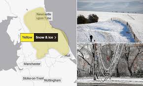
London: A yellow weather warning has been issued for parts of the UK on Saturday with snow, ice and freezing rain forecast.
Freezing rain is one of the most hazardous types of precipitation where liquid water droplets freeze instantly on ground impact.
It can turn roads and pavements into ice rinks very quickly and in more extreme cases the weight of ice can bring down power lines and trees.
With an easterly wind, it has been pretty cold in the UK this week, not helped by the persistent layer of cloud for most of us.
From Brighton, London, Swindon, and Wrexham across to Leeds there have been zero hours of sunshine recorded in the last seven days, compared to 40 hours in north-west Scotland.
On Saturday we’ll be getting a band of rain moving in from the south-west which will clash with colder air in the east and bring some wintry precipitation.
The Met Office has issued a yellow weather warning for snow and ice from 06:00 to 14:00 GMT on Saturday.
Parts of northern England, particularly the north-east, are likely to see some snow. It will fall largely to the east Pennines with 2-5cm for example expected on the North York Moors and Northumberland, and some freezing rain may be mixed in.
The warning says ice over the Pennines, particularly above 200m (656ft) is where the freezing rain is possible.
We’re not expecting widespread ice or disruption from the freezing rain but it’s worth being aware of the hazards it can bring.
Water droplets can exist as liquid in clouds, even when the temperature is a few degrees below freezing – we call it ‘supercooled’ water.
It is only when the droplet comes into contact with something like a microscopic speck of dust, pollen or pollutant – known as a cloud condensation nuclei – that it will then freeze instantly around it.
Snow then starts to fall out of the cloud but as it gets closer to the ground, the air gets warmer until it reaches a layer that will be above freezing.
The snow then melts into rain, which most of the time in the UK, is what we end up experiencing.
However, under certain meteorological situations, there can be shallow layer of air near to the surface that is actually below freezing.
This layer is normally too thin for the water droplets to freeze back into sleet or snow but they are supercooled once again.
Consequently, as they are close to the ground – which is also below zero – the next time they hit a surface the droplet will freeze creating a layer of ice.
Freezing rain is certainly possible over the course of a winter in the UK but we rarely see widespread issues.
Perhaps the biggest event in the UK occurred in January 2004 when gritters around Birmingham were unable to cope with freezing rain and snow. The city’s roads ended up grinding to a halt and causing chaos.
Freezing rain is a bigger hazard in the US where more extreme weather systems can bring widespread winter problems.
It can occur over large areas causing power cuts and creating dangerous driving conditions.
If the layer of ice build up is in excess of 6.4mm (0.25in), the US National Weather Service defines it as an ‘ice storm’.
The last major ice storm to hit the US was in 2023 when half an inch of ice brought down power lines and left around 350,000 homes without power.